


Servicios Personalizados
Articulo
 pdf en Inglés
 Articulo en XML
 Referencias del artículo
 Permalink
Revista Universitaria de Geografía
versión On-line ISSN 1852-4265
Rev. Univ. geogr. vol.26 no.1 Bahia Blanca jun. 2017
Influence of the stream structure on longitudinal gradients of thermal recovery in regulated rivers, Sauce Grande River (Argentina)
Ana Casado*
* Université Clermont Auvergne, CNRS, UMR 6042 GEOLAB, F-63000 Clermont-Ferrand, France. ana_lia.casado@uca.fr
Abstract
Dams and reservoirs alter downstream river water temperatures over a range of time and spatial scale. The thermal effects of dams are more noticeable immediately downstream and may persist along several kilometers. The distance for river thermal recovery depends on a combination of factors driving and buffering heat exchange among the river, the aquifer and the atmosphere. Therefore, such distance varies significantly along regulated rivers.
This study analyzes the influence of the stream structure on patterns of thermal recovery of the Sauce Grande River, Argentina. Nine indicators of topographic, morphologic and hydrologic influence are used in summer and winter water temperatures at eight different sites. Seasonal gradients of thermal recovery were irregular, and the thermal effects of the dam remained the same along 15 km monitored during both periods. Water temperature along the first 8 km was influenced by riparian vegetation and showed seasonal differences related to distinct riparian vegetation density. Irrespective of the season, down water temperatures were progressively influenced by hyporheic and phreatic flow. These findings underline the complex relationship between drivers and buffers of stream water temperature and trigger further research on the ecohydrology of this highly regulated river.
Key words: Regulated Rivers; Water Temperature; Stream Structure; Thermal Recovery; Sauce Grande River.
Influencia de la estructura del cauce sobre los patrones de recuperación térmica en ríos regulados
Resumen
Las presas y embalses alteran la temperatura del agua del río a diferentes escalas témporo-espaciales. Los efectos térmicos de las represas son más marcados inmediatamente aguas abajo y pueden persistir a lo largo de varios kilómetros. La distancia para la recuperación térmica de ríos regulados depende de una combinación de factores que conducen y amortiguan el intercambio de calor entre el río, el acuífero y la atmósfera y, por lo tanto, varía considerablemente a través de diferentes ríos regulados. Este estudio evalúa la influencia de la estructura del cauce sobre los patrones de recuperación térmica del río Sauce Grande, Argentina. El mismo utiliza nueve indicadores de influencia topográfica, morfológica e hidrológica sobre la temperatura del agua estival e invernal en ocho tramos de río diferentes. Los gradientes estacionales de recuperación térmica del río siguieron una curva irregular y los efectos térmicos de la represa persistieron a lo largo de los 15 km de río monitoreados durante ambos periodos. La temperatura del agua a lo largo de los primeros 8 km de río analizados está influenciada por la vegetación riparia, presentando diferencias estacionales vinculadas con la densidad diferencial de vegetación. Aguas abajo, los gradientes de recuperación térmica se ven afectados progresivamente por la influencia del flujo hiperhéico y freático independientemente de la estación considerada. Estos hallazgos resaltan la compleja relación entre los factores conductores y amortiguadores de la temperatura del agua y constituyen la base de futuros esfuerzos de investigación sobre la ecohidrología de este río fuertemente regulado.
Palabras clave: Ríos Regulados; Temperatura del Agua; Estructura del Cauce; Recuperación Térmica; Río Sauce Grande.
Introduction
River water temperature (RWT) is a measure of the concentration of heat energy in a stream relative to the volume of water (Poole & Berman, 2001). Thus, RWT is driven by two principal factors: (i) atmospheric conditions, driving heat exchange to and from the stream, and (ii) the river hydrology, determining the heating capacity of the stream as well as the heat exchange between mixing waters (Ward, 1985; Webb, 1996; Poole & Berman, 2001; Caissie, 2006). Flow regulation by dams represents the greatest source of hydrological alteration of streams and rivers (Petts & Gurnell, 2005), and has direct implications for the thermal regime of the regulated river downstream (Olden & Naiman, 2010). The most common effects of dams releasing water from the bottom of thermally stratified reservoirs (i.e. the hypolimniom) are eduction of summer temperature, increase of winter temperature, and the consequent homogenization (flattering) of the annual thermograph (e.g., -15/+8 °C in the Colorado River, Wright et al., 2009; -3.5/+6 °C in the Ebro River, Prats et al., 2011). In addition, dams reduce the frequency and duration of water temperature extremes (e.g. Green River, Olden & Naiman, 2010), and reduce thermal fluctuations over daily (e.g. Haddeo River, Webb and Walling, 1995; Webb & Walling, 1997), weekly (e.g. Willamette River, Steel & Lange, 2007), seasonal (e.g. Ain River, Poirel et al., 2010) and annual time scales (e.g. Naomi River, Preece & Jones, 2002).
The thermal effects of dams are most marked immediately below the dam and, for many regulated rivers, persist for several tens of kilometres downstream; e.g., 30 km in the Severn River (Cowx et al., 1987), 60 km in the North Tyne River (Archer, 2008), 100 km in the Naomi River (Preece & Jones, 2002), and 260 km in the Qiantang River (Zhong & Power, 1996). The distance for thermal recovery downstream from dams depends on a complex combination of factors including (i) the dam structure and operational procedures controlling patterns of flow downstream (Ward & Stanford, 1979; Petts, 1984), (ii) the energy contributions from the atmosphere, tributaries and the phreatic zone, and (iii) the stream structural components moderating heat exchange to and from the stream (Webb, 1996; Caissie, 2006; Webb et al., 2008). The mechanisms by which the stream structural components influence energy exchanges are the focus of increasing scientific interest. For example, riparian forests are known to create microclimates that buffer energy exchange between the air and the water surface (Moore et al., 2005; Hannah et al., 2008; Malcolm et al., 2008; Garner et al., 2015), and it has been increasingly demonstrated that water temperatures at the water- streambed interface are driven by a complexity of heat fluxes markedly dependent on the relationship between the streambed heterogeneity and the alluvial aquifer structure (Hannah et al., 2009; Krause et al., 2011, Brookfield & Sudicky, 2013).
This study focuses on the Sauce Grande River downstream from the Paso de las Piedras Dam, central-eastern Argentina. Building on previous research assessing the effects of the dam on summer RWT (Casado et al., 2011; 2013), it investigates the influence of the stream structure on patterns of thermal recovery with distance downstream from the dam. The analysis includes a set of nine indicators of the stream topography, morphology and hydrology having potential influence on RWT, and is conducted for two 30-day periods spanning the hottest and the coldest water temperatures recorded during summer 2009 and winter 2010, respectively. In addition to giving continuity to the work of Casado et al. (2011, 2013), this paper summarizes unpublished information on patterns of winter RWT. Thus, it provides the very first assessment of the thermal behaviour of this highly regulated river during two contrasting seasons of thermal stress.
Background
The river Sauce Grande drains a basin area of c. 4600 km² within a dry-temperate sub-mountain plain located in south-western Buenos Aires, Argentina (Fig. 1). The natural river flow regime is perennial flashy (rainfed) and event-driven. Mean daily flow is 3.4 m3 s-1, and peak flows may reach more than 1000 m3 s-1 in few hours (Schefer, 2004). Flow variability is marked, and frequently enhanced by alternating phases of ENSO (Scian, 2000) inducing episodes of drier- and wetter-than-normal climate (Campo et al., 2009; Bohn et al., 2011).
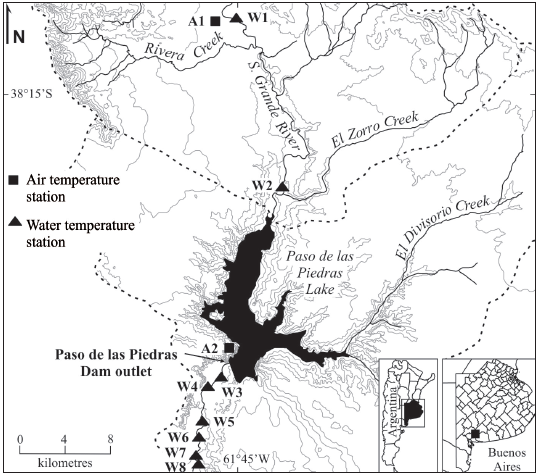
Figure 1. Map of the study area and localisation of air and water temperature gauging sites. Source: modified from Casado et al. (2013).
The Paso de las Piedras Dam impounds the middle river section since 1978 for water supply to a population that today reaches about 350 000 people. Its reservoir has a surface area of 36km², depth of 25 m and maximum capacity of 328 m3106 (Schefer, 2004). The dam stores the totality of inflow volumes, and conserves the reservoir as full as possible to ensure supply in periods of drought. In addition to cause reservoir eutrophication because of long water residence times (Fernández et al., 2011), water-conservation operational procedures cause extreme reduction of downstream flows, all of which affects the water quality of the river section below the dam.
The influence of extreme flow regulation on the water quality of the regulated Sauce Grande was first investigated by Casado et al. (2011, 2013) using river water temperature as hydrological, ecological and water quality parameter. The study was conducted at multiple river sites (W1 to W8; Fig. 1) during a 30-day summer period recording the lowest downstream flows and the hottest air temperatures. The authors found that (i) mean daily water temperatures at the dam outlet were 4.2 °C cooler than those recorded within the upstream sites, and (ii) mean daily water temperatures recorded within the downstream sites remained below the unregulated summer mean (21.4 °C). A similar study was conducted during a 30-day winter period (Casado, 2013). Results revealed that (i) mean daily water temperatures at the dam outlet were 4.2 °C warmer than those recorded upstream, and (ii) mean daily temperatures recorded within the downstream sites rarely dropped below the unregulated winter mean (8.4 °C).
Materials and methods
Water temperature data
This study uses two sets of continuous mean daily water temperature data recorded within the main stream channel at eight different sites located above and below the dam (Fig. 1). The time series span a 30-day summer period ranging from late February to late March 2009 (day 58 to 87), and a 30-day winter period ranging from late June to late July 2010 (day 173 to 202). These periods of high quality data were chosen to assess water temperature response under contrasting hydrothermal stress. Spatial differentiation in absolute water temperatures across sites was inspected by plotting 30-day means versus distance from the dam. Thermal gradients (° C km-1) were calculated as the ratio of temperature differences to distance between consecutive sites.
Assessment of the stream structure
The analysis considers nine indicators of the stream topography, morphology and hydrology influencing heat exchange at the micro-scale (Table I). Stream structural data were collected within eight reference reaches using a combination of field- and GIS-based techniques. The length of the reference reaches is 1500 m upstream from each site where water temperatures were recorded (Fig. 1). This length was selected relative to the total extent of the upstream and downstream river sections monitored (~20 and ~15 km, respectively), and is based on common distances used in other studies linking structural buffers to stream temperature (Hannah et al., 2008; Malcolm et al., 2008; Chu et al., 2010).
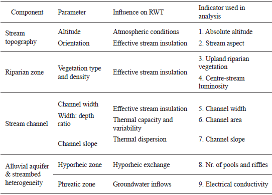
Table I Components of the stream structure influencing river water temperatures. The nine indicators used in analysis are listed along. Source: based on Poole & Berman, 2001.
The riparian zone and the stream channel were digitized using high resolution imagery from March 2009 (Google Earth®). The riparian zone was delimited by the active floodplain, and the stream channel was delineated by the top potions of cut banks and point bars. Upland riparian vegetation was calculated as percentage of channel surface area occupied by woody vegetation. Variations in percentage of upland riparian vegetation during summer and winter were inspected using imagery from June 2009. The stream aspect was determined based on the degree of inclination of the general channel axis with respect to the North (0°). Actual incident light to the stream was measured in the centre of the stream at several sections along each reference reach using a handy digital light meter. Centre-stream luminosity was calculated as percentage of light measured simultaneously in open field; the value used in analysis results from the average of all the observations performed for a single reach. Channel width and depth were measured at several sections using a laser rangefinder of 1.5 mm precision (Impulse Laser tech). The channel slope was calculated based on the difference between streambed elevation in the upper and lower sections of each river reach divided by the reach length (1500 m). The streambed elevation at the lower sections was used as indicator of absolute altitude of the river reaches. The number of pools and riffles was calculated using the relationship of average width to reach length assuming that the spacing between pools averages 5 channel widths (Richards, 1976). Finally, repeated measures of electrical conductivity of running waters (μS cm-1) were performed at each water temperature site using a handy EC tester calibrated at 25 °C (Hanna Instruments). Averaged electrical conductivity per site was used as indicator of groundwater influence on the stream, and therefore of thermal diversity between mixing waters.
Statistical analysis
The similarity between variables of the stream structure was inspected prior to analysis. Similarity analysis used Pearson's correlation coefficients and was performed separately for the summer and the winter periods. The value of each variable per site was calculated as mean (or percentage of coverage) of all observations available so that variables were considered seasonally constant. The degree to which each stream component contributes to explain spatial variations in patterns of thermal recovery below the dam was evaluated using principal component analysis (PCA). Despite the reduced size of the sample data, PCA permitted to reduce the number of variables of potential influence into a set of linear combinations of uncorrelated factors accounting for the greatest cumulative proportion of variance explained.
Results
Gradients of thermal recovery within the regulated Sauce Grande River
The distribution of 30-day mean water temperature with distance from the dam revealed marked spatial shifts during both periods of monitoring (Fig. 2). Dam-induced summer cooling and winter warming were most marked immediately below the impoundment, and declined in the downstream direction as water temperatures increased (in summer) and decreased (in winter) with distance from the dam closure. Yet the thermal effects of the dam persisted along the entire river stretch monitored during both periods of analysis. Mean water temperature at site W8 (river km 15) was 1.1 °C cooler (in summer) and 0.4 °C warmer (in winter) than that recorded within the unregulated river upstream.
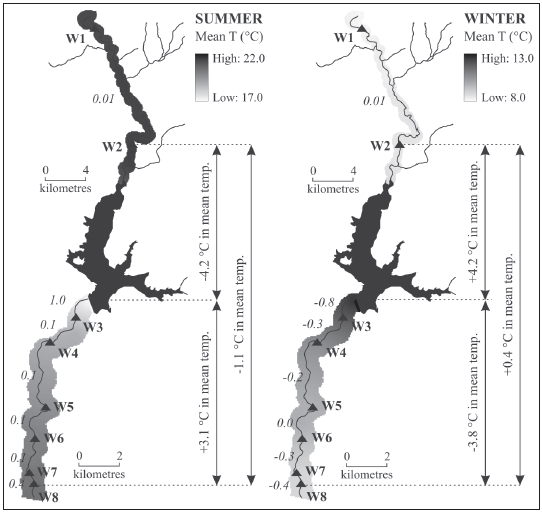
Figure 2. Distribution of 30-day mean water temperatures across sites during summer (2009) and winter (2010). Water temperatures at the dam outlet were recorded on the weir draining reservoir seepage into the stream channel. The scale of representation of the river segment below the dam was increased 2 times. Source: elaborated by Casado.
In addition, warming and cooling trends with distance from the dam were irregular (Fig. 2). Summer gradients of thermal increase were notably high between the dam outlet and site W3 (1 °C km-1), remained relatively steady downstream thereafter (0.1 °C km-1), and increased again within the distal sites (0.4 °C km-1). Winter gradients of thermal decrease varied markedly between sites (0.0 °C > -0.3 °C), defining unclear patterns of thermal recovery. Spatial and seasonal irregularity in patterns of thermal recovery below the dam suggest the influence of the stream structure on water temperature response along the stream.
Stream structure
The absolute altitude of the river sections decreases from 219 m to 119 m. Although a 100 m-difference should have little influence on water temperature behaviour across sites, Casado et al. (2013) found that ambient conditions varied notably between upstream and downstream sites because of the moderating effects of the reservoir lake. Comparison of the stream aspect across reaches revealed no significant variations, as most reaches face SSW, S and SSE (Table II; Fig. 3). However south-facing streams in the southern hemisphere receive lower solar radiation and, depending on the time of the day, light will penetrate better on east- and west-facing stream margins. Irrespective of the aspect of the different reaches, the effective stream insulation throughout the day will depend, among others factors, on the height and density of riparian vegetation along the stream. GIS-based analysis revealed that the proportion of woodlands within the stream channel varies considerably from one reach to another. The percentage of upland riparian vegetation permitted to identify three types of river reaches including (i) mainly grassy reaches, where woods represent less than 30 % of the channel surface, (ii) semi-wooded reaches, and (iii) mainly wooded reaches, where woods represent more than 60 % of the channel surface. Mainly grassy reaches (W1, W7 and W8) are dominated by graminoid species of Stipa developing on the channel banks, and display important associations of pampas grasses along the stream (Cortaderia seollana). With exception of narrow channel sections where pampas grasses may shade a significant proportion of the stream, mainly grassy reaches receive near 100 % of light. On the other side of the scale, mainly wooded reaches (W3 to W5) display dense alignments of willows (Salix humbodltiana) growing along the stream, near to the water surface. In reaches W3 and W5, where the channel is relatively narrow, stream luminosity is less than 5 % in summer and less than 30 % in winter.
Table II. Structural characteristics of the reference reaches delimited upstream from water temperature sites. Absolute values by structural variable across sites were categorized into five magnitude classes relative to the entire river section monitored. Magnitude classes were defined by the inter-seasonal mean ± 0.5s (1 s). Source: elaborated by Casado.
Figure 3. Stream components and hydromorphologic characteristics of the upstream and downstream reference reaches. The downstream scale in the longitudinal view was increased 3 times. (*)Inter-seasonal mean. Source: elaborated by Casado.
Bed channel slope ranges from 0.001 to 0.005, and shows clear relationships with altitude; i.e. the highest gradients are found within the upper reaches (with exception of reach W1 that showed the lowest gradient). The channel geometry showed correlation with altitude as well. The stream channel within the upper reaches is wide and shallow, and becomes progressively narrower and deeper with distance downstream (36 > w:d > 11). This implies that the upper reaches tend to have greater stream surfaces allowing for more rapid heat conduction and radiation, whereas the lower reaches tend to absorb less heat and to be more effectively shaded by vegetation.
The number of pools and riffles (P&R) upstream from each water temperature site was correlated to flow sinuosity. The highest number of P&R was observed upstream from site W5 (61) and site W6 (66); the average distance between riffles is 100 m and the reach sinuosity is 2.1 and 2.3, respectively. In opposition to what was expected, in situ electrical conductivity increased markedly in the downstream direction irrespective of the stream sinuosity during both periods of monitoring. This aspect is strongly linked to the effects of the dam in reducing downstream flows, and in increasing the relative influence of groundwater flow inputs downstream. Inter-seasonal differences in averaged electrical conductivity across sites were comparatively less important, and linked to stream flow variations between periods of monitoring. Upstream from the dam, 30-day mean summer flow was 40 % lower than 30-day mean winter flow (2 m3 s-1). Inversely, 30-day mean summer flow downstream from the dam was 12 % higher than 30-day mean winter flow (0.3 m3 s-1). Thus, the electrical conductivity of running waters upstream from the dam was higher during summer (up to 50 % in site W2), whereas the electrical conductivity of running waters downstream was higher during winter (up to 10 % in site W4).
Influence of the stream structure on seasonal gradients of water temperature recovery
Correlations between stream structural variables were inspected to avoid redundancy (Table III). Significant correlations were found for channel width - area and for altitude - channel width (-area). This occurs because channel width decreases with decreasing altitude downstream, and because the channel area is a function of the channel width. Significant correlations were also found for upland riparian vegetation - centre-stream luminosity during the summer period. Yet these variables are not strictly redundant. Although the percentage of incident light on the stream tends to decrease with increasing percentage of woody vegetation within the channel, it also depends on the relationship between vegetation height and density (effective vegetation shading), channel width (effective shaded area), and stream orientation (effective insulation throughout the day). In addition, woody vegetation along the stream is deciduous. Thus, correlations between upland riparian vegetation and centre-stream luminosity during the winter period are not significant (for α = 0.05).
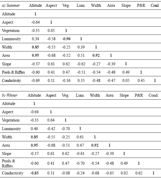
Table III. Pearson's correlation between components of the stream structure during (a) summer and (b) winter. In bold, significant correlations for α = 0.05 (two-tailed test). Source: elaborated by Casado.
PCA was run several times excluding and including the nine variables. The greatest percentage of explained variance was found when removing the channel width during both periods (Fig. 4). The eight remaining variables were assembled into two factors accounting for 81 % (summer) and 78 % (winter) of the total variance (Fig. 4). For both periods, F1 discriminates sites by topographic and morphologic characteristics influencing the thermal behaviour of the stream, whereas F2 is more linked to variables influencing the heat exchange at the air-water surface and water-streambed interfaces (riparian zone and groundwater inflows).
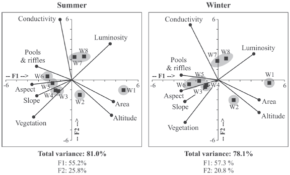
Figure 4. Structure and distribution of water temperature sites as a function of the components of the stream structure. PCA reduced the number of variables of potential thermal influence into a set of linear combinations of two uncorrelated factors (F1 and F2). Source: elaborated by Casado.
Results from PCA permitted to assemble water temperature sites into groups of similar stream structure (Fig. 4). The upstream sites, W1 and W2, are clearly differentiated from the downstream sites by (i) their low sinuosity, low electrical conductivity, and low percentage of upland riparian vegetation, and (ii) their large channels areas. Yet upstream sites were highly scattered from each other during both periods of monitoring. The main difference between sites is given by the channel shape affecting the channel area. The stream channel in site W1 is large and deep (pool-shaped), and so the channel area is larger than that in site W2, where the stream channel is large but shallow (riffle-shaped). Water temperature sites below the dam may be differentiated into three groups exhibiting similar stream structural characteristics, and hence similar patterns of thermal behaviour. Water temperature response in sites W3 and W4 is strongly influenced by high percentage of riparian vegetation (70 %) shading a significant portion of a narrow stream. Although the percentage of upland riparian vegetation in site W5 is also very high (71 %), the overall stream characteristics of this south-facing reach were more related to those of reach W6. The factor that influences water temperatures within these reaches is the overall stream morphology. Both sites exhibit low slope gradients (0.0015), the greatest stream sinuosity (up to 2.3), and therefore the longest length and the largest number of pools and riffles. Finally, sites W7 and W8 are clearly separated by high values of electrical conductivity and luminosity. This indicates that water temperature response within the distal reaches will be markedly influenced by groundwater inflows coupled to high exposure to ambient conditions.
Discussion
Causes of thermal change in the Sauce Grande River
The main effects of the dam on seasonal patterns of river water temperature (RWT) within the regulated Sauce Grande River were (i) reduction of summer temperatures, (ii) increase of winter temperatures, (iii) reduction of diurnal fluctuations, (iv) changes in the timing of diurnal cycles, and (v) increased seasonal constancy (Casado, 2013; Casado et al., 2013). Such changes are common to most regulated rivers in temperate regions (Ward & Stanford, 1979), and respond to dam-induced changes in both components of RWT, the heat load and the thermal capacity of the stream (Poole & Berman, 2001).
Dams releasing water from the bottom of thermally stratified reservoirs affect the heat load of the regulated stream because released flows are thermally out-of-phase with respect to unregulated flows; i.e., reservoir discharges are notably cooler in summer and warmer in winter (Zhong & Power, 1996; Preece and Jones, 2002; Archer, 2008; Wright et al., 2009; Poirel et al., 2010). Despite reservoir discharges did not occur during the periods of monitoring, summer cooling and winter warming within the regulated Sauce Grande River was induced by canalisation of reservoir seepage into the main stream channel. Furthermore, dams control the magnitude, frequency and timing of downstream flows (Petts, 1984), with direct implications for the thermal capacity of the stream. Extreme reduction of downstream flows -such as it has occurred within the Sauce Grande- reduces the thermal capacity of the regulated stream, and hence leads to increased atmospheric influence on the thermal behaviour of the running waters (Webb, 1996; Poole & Berman, 2001). In this regard, Casado et al. (2013) reported that, whilst the dam affected primarily the absolute magnitude of the water thermographs, the frequency, timing and duration of temperature extremes across sites were influenced by ambient conditions without significant differences between the unregulated and the regulated sites.
Potential moderators of thermal recovery below the Paso de las Piedras Dam
Whilst the effects of the dam in altering downstream water temperatures were clear, patterns of thermal recovery with distance from the dam were irregular, and reflected variations between the two periods of monitoring. Seasonal and spatial irregularity in gradients of thermal recovery along the regulated river indicated influence of other external factors driving and moderating heat and water exchanges (in addition to the control exerted by the dam). Whilst atmospheric and hydrologic conditions determine heat and water exchanges at the meso-scale, the structural components of the stream buffer such exchanges at the micro-scale (Fig. 5), and therefore determine the stream resistance to warming or cooling (Webb, 1996; Caissie, 2006).The relationship between channel orientation and shape, together with riparian vegetation height and density influence insulating processes to the stream (Poole & Berman, 2001; Moore et al., 2005; Caissie, 2006). The relationship between the alluvial aquifer, the streambed heterogeneity and the bed materials influence buffer processes resulting from water-bed energy transfers throughout hyporheic and phreatic exchange (Hannah et al., 2004; Caissie, 2006).
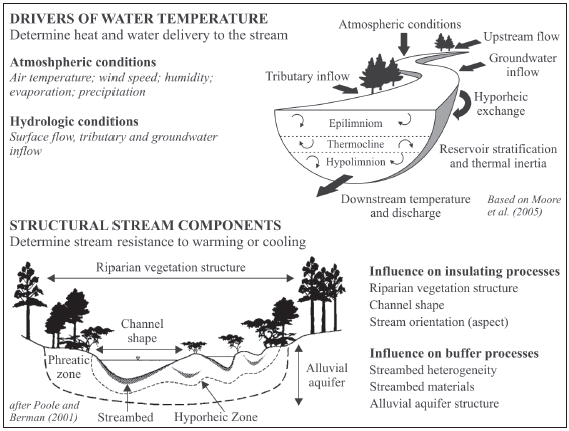
Figure 5. Drivers of river water temperature and insulating/buffering processes within a hypothetic stream. Source: Based on Poole & Berman (2001), Moore et al. (2005), and Caissie (2006).
The relative stream characteristics along the river stretch monitored permitted to assemble water temperature sites into groups of similar stream structure. Upstream reaches were clearly differentiated from each other as well as from the reaches located below the impoundment. The main difference between upstream reaches was in the channel geometry affecting heat exchange at the air/water interface. Whilst reach W2 exhibits a shallow stream, the stream channel in reach W1 is deeper and so the wetted area is notably larger. Large channels have greater potential for heat exchange with the atmosphere because the area exposed to solar radiation is larger and because the effects of riparian shading are less important (Poole & Berman, 2001; Moore et al., 2005). However, deep channels will exhibit greater thermal inertia because of the higher thermal capacity of the stream (Dallas and Rivers Moore, 2011). Irrespective of these differences, both reaches exhibit characteristics common to intermediate streams, where (i) groundwater influence is moderate (relative to the flow capacity of the stream), and (ii) lateral tributaries may have strong influence on water temperatures (Ward, 1985).
River reaches downstream from the dam were clearly separated into three groups of thermal response as water temperatures were more influenced by (i) upland riparian vegetation (sites W3 and W4), (ii) stream slope and sinuosity (sites W5 and W6), and (iii) groundwater inflows within exposed reaches (sites W7 and W8). Riparian vegetation buffers water temperature response to ambient conditions (Moore et al., 2005; Hannah et al., 2008; Malcolm et al., 2008; Garner et al., 2015). As a result, gradients of thermal recovery across the first 8 km below the dam (sites W3 to W5) were low, and remained relatively steady during both periods of monitoring. There were, however, seasonal differences in absolute thermal gradients between sites. Thermal stability across reference reaches was more marked during summer, and linked to dense alignments of riparian willows. Depending on the river section, willows may shade all or a significant portion of the stream water surface. During winter, the influence of upland riparian vegetation is notably less significant because the riparian zone is composed of deciduous species. Thus, reaches cool faster, and the gradients of thermal recovery increase. Downstream from site W5, riparian woodlands are less dense and more discontinuous, and the effects of riparian micro-climates decrease irrespective of the season considered. Thermal stability within this river section is determined by alternating pool-riffle sequences promoting hyporheic exchange along the streambed (Poole and Berman, 2001). The two-way water exchange between the hyporheic zone and the bed channel is often considered as the most important water temperature buffer because of the greater thermal inertia of hyporheic flow (Hannah et al., 2009; Krause et al., 2011). Finally, the thermal behaviour of reaches W7 and W8 is markedly influenced by phreatic groundwater flow entering into an insulated, much reduced stream. Groundwater contributions to small streams typically buffer water temperature extremes because of their annual thermal constancy (Ward, 1985); i.e., groundwater contributions tend to cool water temperatures in summer and to warm water temperatures in winter (Webb et al., 2008). However, in the absence of riparian buffers and in the presence of shallow channel conditions, stream water temperatures may trend rapidly away from groundwater temperature and toward atmospheric temperatures (Poole & Berman, 2001). This latter aspect was reported by Casado et al. (2013), whom found that dominant water temperature regimes within sites W7 and W8 were strongly synchronized with air temperature regimes. Thus, water temperatures within the distal reaches will be more influenced by insulating processes than by buffering processes, and therefore will exhibit higher gradients of thermal recovery.
Conclusions
This study investigated the influence of the stream structure on patterns of thermal recovery with distance downstream from the Paso de las Piedras dam. Results revealed that longitudinal irregularity and seasonal differentiation in patterns of thermal recovery within the regulated Sauce Grande River were strongly linked to variations of the stream structure along the river section monitored. Riparian vegetation buffers energy exchanges immediately below the dam causing thermal stability in summer. Further downstream, thermal stability is linked to the stream sinuosity promoting hyporheic exchange irrespective of the season considered. Despite groundwater contributions to this much reduced stream increase progressively with distance from the dam, water temperature response within the distal, exposed reaches is more dominated by insulating processes, and so gradients of thermal recovery increase. In addition to providing new information on the complex stream structure within the regulated Sauce Grande River, this paper provids the first assessment of the thermal behaviour of this highly regulated river during two contrasting seasons of thermal stress. The greatest limitation for earlier assessment of this fundamental water quality and ecological parameter was linked to the lack of climatic, hydrologic, and water temperature data. In this regard, this investigation provides an important platform to underpin further research on the integrity and health of the river ecosystem.
Acknowledgements
The authors thank the ADA1 Authority, Marta Crisafulli, and the rest of the staff for permitting access to the Paso de las Piedras Dam complex, for providing assistance with equipment installation and survey, and for providing climatic and river flow data. Funding was provided partially by Consejo Nacional de Investigaciones Científicas y Técnicas (CONICET), and by the Research Project PGI 24/G067 "Geografía Física Aplicada al estudio de la interacción Sociedad-Naturaleza. Problemáticas a diferentes escalas témporo-espaciales".
Notas
1 Autoridad del Agua, Ministerio de Infraestructura y Servicios Públicos de la Provincia de Buenos Aires, Argentina.
References
1. Archer, D. (2008). The influence of river regulation at Kielder Water on the thermal regime of the River North Tyne. BHS 10th National Hydrology Symposium (pp. 35-41). Exeter
2. Bohn, V. Y., Piccolo, M. C. & Perillo, G. M. E. (2011). Análisis de los periodos secos y húmedos en el sudoeste de la provincia de Buenos Aires (Argentina). Revista de Climatología, 11, pp. 31-43.
3. Brookfield, A. & Sudicky, E. (2013). Implications of hyporheic flow on temperature-based estimates of groundwater/surface water interactions. Journal of Hydrologic Engineering, 18, pp. 1250-1261.
4. Caissie, D. (2006). The thermal regime of rivers: a review. Freshwater Biology, 51, pp. 1389-1406.
5. Campo, A. M., Ramos, M. B. & Zapperi, P. (2009). Análisis de las variaciones anuales de precipitación en el suroeste bonaerense, Argentina. XII Encuentro de Geógrafos de América Latina (pp. 12). Montevideo.
6. Casado, A., Hannah, D. M., Peiry, J.-L. & Campo, A. M. (2011). Effects of the Paso de las Piedras Dam on the thermal regime of the Sauce Grande River, Argentina. En Chomette, C. & Steiger, J. (Eds.), Ecohydraulics: linkages between hydraulics, morphodynamics and ecological processes in rivers (pp. 239-244). Clermont-Ferrand: PUBP.
7. Casado, A. (2013). Human impacts and fluvial metamorphosis. The effects of flow regulation on the hydrology, morphology and water temperature of the Sauce Grande River, Argentina (Tesis doctoral inédita). Université Blaise Pascal Clermont-Ferrand II - Universidad Nacional del Sur, Clermont-Ferrand.
8. Casado, A., Hannah, D. M., Peiry, J.-L. & Campo, A. M. (2013). Influence of dam-induced hydrological regulation on summer water temperature: Sauce Grande River, Argentina. Ecohydrology, 6, pp. 523-535.
9. Chu, C., Jones, N. E. & Allin, L. (2010). Linking the thermal regimes of streams in the Great Lakes Basin, Ontario, to landscape and climate variables. River Research and Applications, 26, pp. 221-241.
10. Cowx, I. G., Young, W. O. & Booth, P. (1987). Thermal characteristics of two regulated rivers in mid-Wales, U.K. Regulated Rivers: Research & Management, 1, pp. 85-91.
11. Dallas, H. F. & Rivers Moore, N. A. (2011). Micro-scale heterogeneity in water temperature. Water S.A., 37, pp. 505-512.
12. Fernández, C., Parodi, E. R. & Cáceres, E. J. (2012). Phytoplankton structure and diversity in the eutrophic-hypereutrophic reservoir Paso de las Piedras, Argentina. Limnology, 13, pp. 13-25.
13. Garner, G., Malcolm, I. A., Sadler, J. P., Millar, C. P.& Hannah, D. M. (2015). Inter-annual variability in the effects of riparian woodland on micro-climate, energy exchanges and water temperature of an upland Scottish stream. Hydrological Processes, 29, pp. 1080-1095.
14. Hannah, D. M., Malcolm, I. A., Soulsby, C. & Youngson, A. F. (2004). Heat exchanges and temperatures within a salmon spawning stream in the Cairngorms, Scotland: Seasonal and sub-seasonal dynamics. River Research and Applications, 20, pp. 635-652.
15. Hannah, D. M., Malcolm, I. A., Soulsby, C.& Youngson, A. F. (2008). A comparison of forest and moorland stream microclimate, heat exchanges and thermal dynamics. Hydrological Processes, 22, pp. 919-940.
16. Hannah, D. M., Malcolm, I. A. & Bradley, C. (2009). Seasonal hyporheic temperature dynamics over riffle bedforms. Hydrological Processes, 23, pp. 2178-2194.
17. Krause, S., Hannah, D. M.& Blume, T. (2011). Interstitial pore-water temperature dynamics across a pool-riffle-pool sequence. Ecohydrology, 4, pp. 549-563.
18. Malcolm, I. A., Soulsby, C., Hannah, D. M., Bacon, P. J., Youngson, A. F.& Tetzlaff, D. (2008). The influence of riparian woodland on stream temperatures: implications for the performance of juvenile salmonids. Hydrological Processes, 22, pp. 968-979.
19. Moore, R. D., Spittlehouse, D. L. & Story, A. (2005). Riparian microclimate and stream temperature response to forest harvesting: a review. Journal of the American Water Resources Association, 41, pp. 813-834.
20. Olden, J. D. & Naiman, R. J. (2010). Incorporating thermal regimes into environmental flows assessments: modifying dam operations to restore freshwater ecosystem integrity. Freshwater Biology, 55, pp. 86-107.
21. Petts, G. E. (1984). Impounded Rivers. Chichester: John Wiley & Sons.
22. Petts, G. E.& Gurnell, A. M. (2005). Dams and geomorphology: Research progress and future directions. Geomorphology, 71, pp. 22-47.
23. Poirel, A., Gailhard, J. & Capra, H. (2010). Influence des barrages-réservoirs sur la température de l'eau : exemple d'application au bassin versant de l'Ain. La Houille Blanche, 4, pp. 72-79.
24. Poole, G. C. & Berman, C. H. (2001). An ecological perspective on in-stream temperature: Natural heat dynamics and mechanisms of human-caused thermal degradation. Environmental Management, 27, pp. 787-802.
25. Prats, J., Armengol, J., Marcé, R., Sanchez-Juny, M. & Dolz, J. (2011). Dams and reservoirs in the lower Ebro River and its effects on the river thermal cycle The Handbook of Environmental Chemistry, 13, pp. 77-95.
26. Preece, R. M. & Jones, H. A. (2002). The effect of Keepit Dam on the temperature regime of the Naomi River, Australia. River Research and Applications, 18, pp. 397-414.
27. Richards, K. S. (1976). The morphology of riffle-pool sequences. Earth Science Reviews, 1, pp. 71-88.
28. Schefer, J. C. (2004). Los recursos hídricos y el abastecimiento de agua. Bahía Blanca: CEPADE.
29. Scian, B. (2000). Episodios ENSO y su relación con las anomalías de precipitación en la pradera pampeana. Geoacta, 25, pp. 23-40.
30. Steel, E. A. & Lange, I. A. (2007). Using wavelet analysis to detect changes in water temperature regimes at multiple scales: effects of multi-purpose dams in the Willamette River Basin. River Research and Applications, 23, pp. 351-359.
31. Ward, J. V. & Stanford, J. A. (1979). Ecological factors controlling stream zoobenthos with emphasis on thermal modification of regulated streams. En Ward, J. V.& Stanford, J. A. (Eds.), The Ecology of Regulated Streams, Proceedings of the First International Symposium on Regulated Streams (pp. 35-55). New York: Plenum Press.
32. Ward, J. V. (1985). Thermal characteristics of running waters. Hydrobiologia, 125, pp. 31-46.
33. Webb, B. W. & Walling, D. E. (1995). The long-term thermal impact of reservoir operation and some ecological implications. Man's Influence on Freshwater Ecosystems and Water (pp. 245-257). IAHS Publications.
34. Webb, B. W. (1996). Trends in stream and river temperature. Hydrological Processes, 10, pp. 205-226.
35. Webb, B. W. & Walling, D. E. (1997). Complex summer water temperature behaviour below a UK regulating reservoir. Regulated Rivers: Research & Management, 13, pp. 463-477.
36. Webb, B. W., Hannah, D. M., Moore, D., Brown, L. E. & Nobilis, F. (2008). Recent advances in stream and river temperature research. Hydrological Processes, 22, pp. 902-918.
37. Wright, S. A., Anderson, C. R .& Voichick, N. (2009). A simplified water temperature model for the Colorado River below Glen Canyon dam. River Research and Applications, 25, pp. 675-686.
38. Zhong, Y. & Power, G. (1996). Environmental effects of hydroelectric projects on fish resources in China. Regulated Rivers: Research & Management, 12, pp. 81-98.
Fecha de recepción: 29 de marzo de 2016
Fecha de aceptación: 10 de noviembre de 2016
© 2017 por los autores; licencia otorgada a la Revista Universitaria de Geografía. Este artículo es de acceso abierto y distribuido bajo los términos y condiciones de una licencia Atribución-NoComercial 2.5 Argentina de Creative Commons. Para ver una copia de esta licencia, visite http://creativecommons.org/licenses/by-nc/2.5/ar/deed.es_AR
